


Show all 33 photos
Mount Malinovaya is part of the Malidak ridge, which includes the first, second and third Malinovka and Mount Kirel.
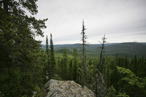
Its slopes are covered with rocky placers - kurumniks. In summer (July, August), ripe, large, fragrant raspberries cover the entire kurumnik and from a distance it seems that the stones are raspberry-colored. In addition, from the top of the mountain almost the entire southern part of the Ural Range is visible.
The most accessible and beloved peak among tourists is First Malinovka. It was there that the “Stone Bag” episode of the famous film epic “Eternal Call” was filmed.
Mountaineering competitions (rock class) of the Volga and Ural Federal Districts are also held annually on Pervaya Malinovka.
The first part of the route runs along the southern slope of the Malidak ridge and passes through a pine forest with a small number of birch and aspen trees. On the northern slope - where the second half of the route passes - there are fir and spruce forests.
In the spring, Beloretsk residents on the slopes of Malinovka collect the so-called kislyanka - this plant is correctly called alpine taran (knotweed), of the buckwheat family. It makes excellent pies, some people make compotes, and even in its raw form it is excellent. Quenches thirst. You can also pick blueberries, lingonberries, and raspberries in July and August. Malinovka is also famous for its mushrooms - boletus, boletus, boletus, saffron milk caps, and milk mushrooms.
It is important to know
Limitations and Features
The Mountain Malinovaya route is a one-day mountain hiking route in the Beloretsky region of the Republic of Bashkortostan to Mount Malinovaya (1152m). From the beginning of the trail to the top of the First Malinovaya is about 3 km, the top of the third is another 3 km, and from the top of the third to the village of Otnurok is also about 6 km. The elevation gain is about 500-600m.
The route is quite easy to follow. No complex obstacles requiring special knowledge, skills or equipment are required. Accessible for beginners and tourists with children.
The route can be walked in different ways: in one day you can reach the first Malinovka and return back, in one day you can go through all three peaks and go down to the village of Otnurok, or according to the second option, go slowly and spend the night under the third Malinovka (or under the second), and at dawn, climb to the top and understand why the mountain was called Raspberry (according to one version).
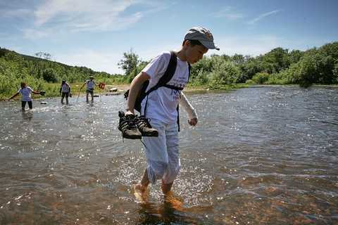
At the beginning and at the end of the route it is necessary to ford the river. In summer and autumn it is not difficult and safe. In spring, during high water, it is better by transport or bypassing the bridge. In winter, the river freezes; around the end of November it is already possible to cross on the ice.
It is worth remembering that in the Malidak ridge area there are bears. There are a lot of raspberries here, and bears love them. But, if you follow the path strictly, you will not encounter a bear.
But in the summer it is better to take care of insects, in particular mosquitoes, in advance by taking the appropriate repellent with you. Also, we should not forget about ticks, which are abundant in this region. Therefore, it is recommended to walk the route in closed pants, which prevent insects from free access to open areas of the body.
Along the route, there is cellular communication almost everywhere. There is even internet at the peaks.
How to get there
The route passes through the Beloretsky district of the Republic of Bashkortostan.
Nearest cities: Beloretsk (start within the city).
The starting point of the route can be reached by car, or by any public transport route that goes to the Oktyabrsky village. You need to get to Malinovaya Street, from there you can clearly see all three peaks.
You can get back from the village of Otnurok to the city of Beloretsk by taxi, ordering it in advance. Distance ~15 km (journey approximately 45 minutes).
Places for rest and overnight stays
You can park and, if you wish, camp at the second or third Malinovka.
In the village of Otnurok you can spend the night at the Malinovka base, and also order a bathhouse from them. The base is wonderful, the staff is helpful, there are horses, you can ride.
Rest spots are also indicated in the detailed description of the route.
Water
There are several streams and springs with drinking water along the route. During dry periods they may dry out, it is better to have water with you to drink.
The shops
The route itself passes outside populated areas. Make purchases before starting your journey in Beloretsk.
Don't forget to take it with you
- Supplies of food and drink.
- Personal and group equipment.
- Repellent, mosquito repellent.
Detailed route description
Photo by E. Petropavloskaya
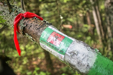
Moving along Malinovaya Street towards the mountain you need to reach Gogol Street. On the right as you move, you will see a sign with the inscription “Robin”. We go down Gogol Street and reach the river. This is the Nura River. We move upstream the river along the embankment road. After about 2.5 km, you need to turn left towards the river, along a dirt road. From there you can already see marks on the trees.
The marked route begins. The first small obstacle is a ford across the Nura River. In summer, usually no higher than the knee, even for a child. But in the spring, during high water, it is better to refrain from wading. It’s better to cross in some serious transport, like a UAZ, or go around the bridge (but that’s a completely different story). Through Nura - fun and fresh, someone will definitely “dip” in the cool water.
A short walk in a straight line and the ascent begins. First rest at a large anthill. It takes 15-20 minutes to get there. There are not many meters there, no more than 1.5 km from the ford, but the steepness of the slope forces you to slow down a little.
After a rest, the walk becomes more fun, after about 10 minutes there is a small ravine on the right - there is a spring, popularly called Koroviy. Local historians say that it was there that the famous rebel Emelka Pugachev once stopped and drank some water while crossing the Ural Mountains, where their fate brought them together with Salavat Yulaev, the Bashkir national hero. Maybe this is just a legend, but all Beloretsk residents believe in it. The region here is famous.
From the Cow Spring the road goes sharply uphill. After 15-20 minutes there is a fork. From the start of the route about 2 km.
The right path goes to the foot of the first Malinovka. And the left one goes further along the ridge to the peaks of the second and third.
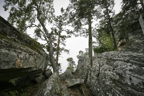
A rocky massif, up to 80 m high, stretching into the piercing blue sky. It’s not for nothing that the directors chose this particular place to shoot the film “Eternal Call.” It’s very beautiful here, and there’s a magnificent overview of all the Beloretsk surroundings from the highest point.
No special equipment is required for climbing. You just need to carefully follow the guide's instructions. But if suddenly you are a rock climber and you want to try your hand, and there are all the conditions for this.
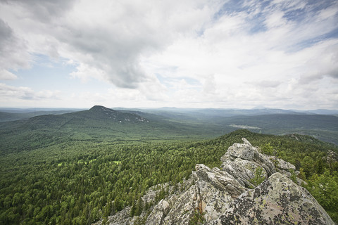
At the top you feel like a real climber! Arm yourself with a camera and create! The sharp peaks of the Second and Third Malinovka, Mount Kirel, the rocky outcrops of Yalangas, the harsh Yaman-Tau, the Crane Swamp - such photo landscapes will serve as an excellent gift for loved ones.
“Before you go up a mountain, think about whether you can go down it,” said one of the greats. In fact, the descent does not present any particular difficulties, you just need to know the treasured paths, otherwise the insidious Leshy will lead you into the thicket, and this is the worst option. After climbing the mountain, having a snack on an improvised table made of stone slabs seems simply magical. Needless to say, Malinovka knows how to welcome guests!
In order to continue our route and climb to the main peak, you need to go down from the first Malinovka to the fork and continue your way further. And then a short traverse along a picturesque road awaits us. It's easy to walk because there is no climb. You can have a leisurely conversation, you can only admire the local flora in this area; the tops are not yet visible. Forest areas give way to clearings, and after about 2 km on the right along the direction of travel there will be a large hayfield. To the left of the path at the very beginning of the clearing, there is a small spring where you can get clean water. And from the clearing the peaks of the second and third Malinovka are visible.
Here, between the second and third Malinovka, the trail crosses the ridge and takes us to its northern slope. For those wishing to complete the route overnight, you can spend the night here. And in the evening run to the second Malinovka.
The second Malinovka is not as picturesque as the first, which has rocks, and is as high as the third. That's why they don't go up there often. These are mainly scattered stones (kurumnik) and small rocks at the very top.
Having collected the purest water in the spring, we move on. A slight ascent begins and more and more often we have to cross stone placers. It should be remembered that there are ticks here, and these insects are found here until September. Therefore, it is worth protecting yourself. Dress properly so that ticks cannot get through and you can even treat with special means.
After about 2 km, after crossing another stone river, the path forks. Its right part goes down to the village of Otnurok, and the left part goes up to the main peak.
The ascent from the fork takes 20-30 minutes.
The path is obvious, it is almost impossible to go aside or get lost. The inscription: “To the mountain” will definitely lead you to your cherished goal!
Already on the approaches to the top, beautiful views open up!
Finally we find ourselves in the circus of the third Robin. There is a small parking lot (you can place two small tents) where you can spend the night. But you should remember that there is no stream there and therefore you need to bring water with you.
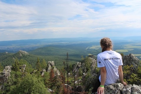
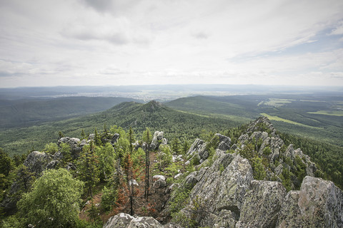
And now the long-awaited moment - we are at the top of Raspberry Mountain. Here they are, the treasured 1152 m above sea level. The entire southern part of the Ural ridge opens up to our view. From here, from the top, you can outline the routes of your future hikes, because the entire Great South Ural Trail is visible.
Having admired the beauty enough, we go down. And we move towards the village of Otnurok. The entire route from the top of the third Malinovka to the village of Otnurok is 6 km. You can complete it in 1-1.5 hours. Below is a ford across the Nura River. Here, in the upper reaches, the river is smaller than at the beginning of the route.
The route ends in the village of Otnurok. There is a sign on the outskirts.
The village of Otnurok was once large, there was even a primary school here. Now it is practically a holiday village. There is also a tourist center “Malinovka”. You can arrange in advance, and a magnificent bathhouse will be ready for your arrival. This will be the logical conclusion of the route. From the village of Otnurok to the city of Beloretsk you can take a taxi. Only about 15 km.
This route is also unique in that it is universal. It can also be walked in the opposite direction. You can make radial exits from Beloretsk to the first Malinovka and return to the city again. You can come to the village of Otnurok and stop for a tour. base and go on a radial route to Malinovka 3!
6 kilometers from the city of Beloretsk there is the beauty of the local area - Raspberry Mountain. Already approaching the city itself from Magnitogorsk, Uchalov and Ufa, travelers can see the peaks of Malinovaya. Climbing onto one of them (there are three in total), an extraordinary luxurious landscape appears. You can see the city of Beloretsk from above, Yamantau 1640 m high, ridge Inzer Tooths, Kirel 1162m, Yalangas 1297m, Big Shelom And Iremel 1582 m.
The mountain itself has several names: Raspberry Ridge, Malinovka, Raspberry Mountains, but their meaning remains the same - there is a great abundance of raspberry berries, this is also typical for the Bashkir - “Elektash”, in the pass Berry Stone. On the slopes, the terrain mainly consists of kurumniks - rocky placers. From July to the end of summer, the kurumnik is overgrown with large, ripe and fragrant raspberries. At a fair distance, the stones may appear to take on a crimson color.
The vertices together form a crescent shape. The first of them is a rocky fortress with walls and reaches a height of 70 m. The second is a kilometer-long gigantic mountain, with a steep peak rise in the east. The third is considered the main one and, accordingly, the highest, its height is 1152.3 m.
Raspberry Mountain has a neighbor - Mount Kirel in the shape of a cone, together they create a ridge called Malidak.
At all times of the year, Robins stun with their splendor. But the season itself is autumn, where a wide color palette of crimson aspens, coniferous spruces and yellowing birches opens up for you.
In the 50s, the film “Eternal Call” was filmed in these places. Many residents took part in the filming, keeping memorable photographs with the actors depicted in them.
For many, Malinovka is interesting for its opportunity to get amethyst crystals. They are a type of quartz. In ancient times, it was used in the manufacture of boxes and all kinds of elegant jewelry.
Berries and plants of Raspberry Mountain
The beginning of spring serves as an excellent occasion for collecting sourweed (plants of the buckwheat family), which is what Beloretsk residents actively do. You can make delicious hearty pies and compotes from it, but even in its usual raw form it is edible and can perfectly quench thirst. Among other things, local residents also collect blueberries and lingonberries. Malinovka is known for its mushroom spots with an abundance of butter mushrooms, porcini mushrooms, boletus mushrooms, saffron milk caps and milk mushrooms.
Using two methods you can easily reach the foot of the mountains. The first one is from the side village Kuzgun-Akhmerovo, and the second from the north is a farmstead Otnurok. Also near the farm there is a tourist base “Malinovka”, from which you can go on a walking or horseback journey to any of the nearest peaks in the surrounding area.
Plan of a one-day route Beloretsk – Malinovka (1st peak) – Malinovka (3rd peak) – Otnurok.
They get to the original place of our route using a car or city transport heading to the Oktyabrsky village. You need to get to Malinovaya Street, from there you can see a view of each of the three peaks.
You can easily travel the way back from the village of Otnurok to Beloretsk using a taxi, which it is advisable to order in advance. The distance is 15 km (takes approximately 45 minutes).
From the beginning of the path to the first peak you have to cover a distance of about 3 km, to the third - 6 km, and from the third to the village of Otnurok approximately 6 km.
The route is very easy to overcome. There are no difficult obstacles, no specific skills, abilities or specialized equipment with equipment is required. Ideal for beginners in hiking and tourists with children.
The route starts from the southern side of the Malidak ridge and continues into a pine forest, where you can typically find birch and aspen trees. Further, the route runs on the server side of the slope, surrounded by fir and spruce forests.
The route passes through several streams and drinking water springs. But sometimes they can dry out, depending on weather conditions, so it is recommended to take drinking water with you. At the starting and ending points of the route you will have to ford the river. In summer and autumn, this process is not difficult and is completely safe. But in the spring, during high water, you should go around the bridge or use transport. In winter, the river is covered with a layer of ice; usually from the beginning of December you can move freely along it.
It is important to remember that it is possible to encounter a bear on the Malidak Ridge. There are plenty of raspberries on it, and they are their favorite delicacy. Therefore, it is important to move only along the road, in this case the bear will not overtake you.
Detailed description of the universal route along Raspberry Mountain
Moving along the street. Malinovaya in the direction of the mountain you need to get to the street. Gogol. On the right side of the path, a sign with the inscription “Robin” awaits you. We continue down the street. Gogol below and we get to the river. Before us is R. Nura. We move up in the direction of the river flow, along an embankment road. After approximately 2.5 km, you will need to turn left towards the river and onto a dirt road. After this, marks on the trees will appear along the way.
The marked route starts from here. The first obstacle is the ford across the Nura River. Next, there is a short straight ahead followed by a climb. Next to a large anthill, let's stop to rest. The altitude in this place is small, no more than 1.5 km from the ford, but the slope is steep and you have to slow down a little.
After about 10 minutes, a small ravine will appear on the way - there is a spring there, popularly called Cow. Local historians claim that the famous rebel Emelyan Pugachev stopped at this place to rest and drank from the spring. It is quite possible that this is all just a legend, but local residents believe it
After the spring, the road slopes upward. After 15-20 minutes there will be a fork in front of you. At this stage, 2 km of the path has been covered.
The right path leads to the base of the first peak, and the left to the second and third Malinovka.
While on the first Malinovka, you will see how rock formations reaching a height of 80 m go into the endless blue sky.
After the first peak, continuing our path, we need to go back down to the fork and take the left path. A pleasant traverse along a graceful path awaits you. There is no climb here, so imagine it as if you are on a walk. The forests will be replaced by clearings, and after about 2 km, a huge hayfield will appear in front of you on the right. On the left side there is a small spring where you can get drinking water. Already from these places you can see the second and third peaks.
Located between the second and third Malinovka, the road lies at the intersection of the ridge and leads to the northern slope. We'll spend the night here. In the evening, if you want, climb the second peak.
The second Malinovka is not very spectacular compared to the first, and because of this it is not very popular for climbing. In general, the local picture is represented by the kurumnik and small rocks near the top.
We continue moving. As you climb the northern slope, kurumniks begin to appear more often. It is important to consider that ticks are found in this area until the beginning of autumn. When protecting yourself from insects, you should take safety measures - wear clothing that covers the entire body and, if possible, treat with specialized aerosols.
After about 2 km, having crossed another river of stones, the road flows into a fork. The right path will lead to the village of Otnurok, the left to the third Malinovka.
The climb from the fork to the third peak will take about half an hour.
The path is straight, it is difficult to go astray and get lost. A sign with the inscription “To the mountain” specifically indicates the path to your desired goal!
As you approach the top, magnificent views of the third Robin open up in front of you.
In this place there is a small parking lot where you can place two tents for an overnight stay. It is very important not to forget that there is nowhere to get water in these places, so you need to take it with you.
Magnificent view from Malinovka
Before our eyes there is a view of the entire southern region of the Ural Range. Here, observing from a great height, you can make plans for future hikes, because before your eyes in its entirety: the Great South Ural Trail.
Having enjoyed the scenery enough, we begin our descent back, heading to the last point of the route – the village of Otnurok. The length of the upcoming path from the third peak to the village of Otnurok is 6 km. It takes about an hour and a half to overcome. The ford of the Nura River also awaits us again. Here, in the upper reaches, the river is narrower than at the beginning of the journey.
The hike ends with an arrival in the village of Otnurok.
I rarely go hiking, I mostly do car camping in a Chevrolet Niva. But in a couple of weeks we got together with some work friends to go hiking Mount Raspberry. It is located 6 km from Beloretsk.
There are very few descriptions of this mountain, despite the fact that it is a mountain above 1000 meters, and there are not many of them in Bashkiria. Blogger Rais helped with advice.
We left at six o'clock in the morning as a team of five people, two girls and three guys. As standard, we drove the turn at night, and especially in winter it is not interesting. We got to Beloretsk quite quickly, since the highway was empty at that time.
On the way we met the dawn, the sun was rising over a foggy valley between the mountains.


After driving a little around Beloretsk, we turned onto Malinovaya Street. We left the city along it and moved along the road to the village of Otnurok. About halfway we turned through the snowdrifts into a forest. Here, having changed clothes, we set out on the mountain.

They took with them, which, due to the lack of tracks, showed the distance to the point. The first and main goal was Mount Pervaya Raspberry, it is part Malidak ridge, which consists of the Second Raspberry, the Third Raspberry and Mount Kirel, which looks more like a hill.
Another name for the Raspberry Mountains is the Berry Mountains, these names are associated with the fact that a lot of raspberries grow on the mountains.
From the place where we left the car, we had to walk about three kilometers to Pervaya Malinovaya along a well-trodden path through a coniferous forest. A group of tourists, consisting of an elderly man and several schoolgirls, passed right in front of us.
We caught up with them at a fork, the man said that if you go in one direction, you can walk to Pervaya Malinovaya, about 500-600 meters, if in the other, then to Third Malinovaya and walk about four kilometers to it.
We went to Pervaya Malinovaya, the girls who were walking with us got a big lead, but we kept catching up with them all the way.
Having reached the mountain, we saw a high, long wall of rock. You can’t climb this rock directly, so we walked around along the path on the right and thus gradually climbed to the very top. We were lucky and the weather was clear, so the mountain offers beautiful views in all directions, with fog still visible in some places.


On one side, the whole of Beloretsk is visible at a glance.

On the other hand, the highest mountain of the Southern Urals, Yamantau, can be seen in the distance.


Also in the distance you can see Big Shelom, the same man told us all this.

Having walked along the entire First Malinovaya, we decided to try to go straight to the Second and Third. We found a covered path and went down it to a fork. We went straight to Second Raspberry, but the trail suddenly ended and we began to make our way through waist-deep snowdrifts. Having decided that in this way we would take a very long time to get there and waste a lot of time, we turned back to the fork, went to the third direction, along it we reached the intersection from which we had to walk four kilometers to Third Malinovaya.
The path to it is narrower, it is clear that much fewer people walk along it. The further we walked, the narrower it became. Despite the fatigue, no one wanted to turn back, because there was beauty all around: spruce trees covered with caps of snow, traces of various animals in the snow, a tree all in splinters and many other beautiful and interesting things. And of course, fresh air plus warm tea from thermoses.


We followed the narrow path to the place where it ended. And in front of us there was a small rock that we could climb onto or on the left along the slippery stones, which is what two of us did. Or on the right through deep snowdrifts, I walked ahead in chest-deep snow. Out of habit, I was exhausted and very wet, but I still went upstairs happy.


The main danger was the gaps between the stones, where we sometimes fell chest-deep or waist-deep.

Having walked around the rock a little, we found a more or less flat place and began to climb up it. The girls were in front again.


Grabbing onto trees and stones, we finally climbed up. To a height of 1054 meters. There was also a small rock nearby, which was no longer realistic to climb, although I really wanted to. After all, from the Third Malinovaya, the highest of the three, there is a view of Iremel.


After sitting and taking photos at the top, we headed back. For the whole day we walked 15 km, including uphill and through snowdrifts, we got to the car 10 minutes before sunset, all wet, tired, but happy. From the conclusions: you need to take ice cubes with you, then the return journey will be faster and more enjoyable. This time I took a walkie-talkie with me, which turned out to be very convenient.


We arrived home in Ufa after midnight.
Apparently, now we will go there in the summer to visit the Second Raspberry and climb to the very top of the Third Raspberry.
Where to relax in Bashkiria? This is my most popular question this summer. We got a weekend tour. So that life doesn’t seem like raspberries, I went on another trip around my beloved republic. The decision was made very suddenly and therefore it turned out that during that still hot period all the hotels in interesting places in the Beloretsk region were occupied, but suddenly a certain tourist center “Malinovaya” was found next to the unpopular mountain Malinovaya not far from Beloretsk. The last 20 minutes of the journey are along a gravel road in a picturesque and very tasty coniferous forest, an ancient wooden bridge over a river and now we are greeted by a crimson sunset...
We immediately liked the Raspberry camp site - the mysterious coniferous forest and detached houses with berry names: Cowberry, Cherry and Raspberry, in which we moved in. 500 rubles per night per person, and everything is very clean, there are a couple more rooms on the same floor with us, and downstairs, like in a real village house, there is a kitchen in which local hostesses prepare food for guests, and a common dining room with a fireplace.
They feed us simply porridge and pies, but everything is delicious. There is always free tea, jam and cookies on the tables.
We go up to the second floor to the rooms
Modest, but very clean and the bed linen is not shabby.
So cozy and cool, there were also two bathrooms with showers and cute kittens, everything was like in a real village with relatives.

There are a lot of interesting things on the territory: children's playgrounds, several bathhouses, rabbits and their own horses, which constantly mysteriously ring the bells on their necks, which gives this place some kind of mysticism at night, when you walk alone through the pine trees from the bathhouse to the house and it seems that -you'll take part in a movie about vampires)))
By the way, the barbecue areas are free for guests and are equipped with everything necessary - gazebos, stoves, an outlet and even a sink for washing hands.
Well-fed and steamed in the bathhouse, we slept well and the next morning we set out to conquer the mountain. Not Iremel (1589 meters ) of course, the height of Raspberry Mountain1152 meters above sea level. We thought that we could manage it in three hours and went to look for the mountain; the locals along the road didn’t know how to go there at all, apparently they hadn’t even walked in their entire lives))))
From the wooden bridge to the right along the track into the forest

We are a small company, only three people - two horsemen and me :)

Throughout the entire ascent, the road is marked with red and yellow ribbons and markers, making it extremely difficult to get lost. Most of the way you walk on an almost flat surface, sometimes it even seemed as if we were descending rather than ascending.
We walked slowly and in a couple of hours we reached the equipped parking area, there is also an excellent spring. Very tasty water! But this is the only outlet of the spring along our route, so you can only collect water once, but that’s enough.


Raspberry Mountain got its name, of course, not for its color, but because a lot of raspberries grow here. By the way, at the foot of the Malinova River near the Nura River, a large bard festival “Crimson Accord” is held every year, and the “In a Stone Bag” episode of the film “Eternal Call” was once filmed here. But, despite all this, for some reason the mountain did not become popular. If Iremel is like Red Square and has up to 1,500 tourists a day, then here we met only two families on the mountain.
The climb became difficult in the last half hour - it became quite steep uphill, not so much that it was difficult to climb, but it was a bit difficult to walk. Some people only reach this place; here the forest ends and a good view opens up. But we went to the end! The mountain has three peaks and there is no huge walking plateau; if you climb onto a rock, take a photo and let someone else go.

The view is amazing!

A little glamor)))

Complete zen!

The whole hike took us about 4.5 hours, but we were in no hurry. Professionals here organize speed climbing competitions every fall, this time it will be on September 27th, it seems. They probably fly up the mountain in two hours, or even less))))
Bottom line: I highly recommend the recreation center as an opportunity to go somewhere for the weekend; they also organize rafting, mountain climbs in jeeps, snowmobile excursions and much more. But I don’t recommend horseback riding HERE. As one local employee admitted: horses are fed very little and poorly trained by some not very experienced village guys, as a result, there were cases when people’s horses could not budge from their place on a sleigh, and once a mare carried so much that a woman fell and received concussion - of course they don’t provide helmets here. Therefore, everything is fine here, but it’s better not to approach the horses.
Happy travels!
The stone river Kurum is a large scattering of stones, one of the amazing natural phenomena of the Ural Mountains. It is a pile of huge stone blocks weighing from hundreds to thousands of kilograms each. This river was formed as a result of the destruction of mountains. Over time, the stones gradually slid down the mountain slopes and formed a scattering in the form of a stone river. The length of the river is about two hundred meters. ...
Monument to Tverdyshev (Beloretsk)
Monument to the founder of the Voskresensky copper smelter and Preobrazhensky metalworking plant - (their history, location and photographs can be viewed on our website) - Ivan Borisovich Tverdyshev. The attraction is located on the territory of OJSC "Blagoveshchensk Reinforcement Plant" in the city of Beloretsk, Republic of Bashkortostan. Opening of the monument to I.B. Tverdyshev was held in...
Arsky stone
The outcrop of limestone rocks on the surface of the earth, a historical and geological natural monument. Arskaya rock is located on the territory of the Beloretsky district of the Republic of Bashkortostan next to the village of the same name. The nearest large city is Beloretsk, located 14 km northeast of the attraction. The Arsk rock is about 30 meters high. The place is interesting because, thanks to centuries-old processes of erosion and...
Mount Cherry
One of the attractions and mountain peaks of the Ural ridge is Mount Vishennaya, 836 meters high. Mount Vishennaya is located in the Republic of Bashkortostan, 4 km south of the village of Lomovka and 7 km from the city of Beloretsk. The top of the mountain is represented by a sharp rocky peak, which has on one side (northern) a steep slope exposing rock, and on the other (southern) a gentler slope with vegetation. The mountain is covered...